Line 26:
Line 26: '''...[http://portlandwiki.org/Cascadia_subduction_zone MORE...]'''
'''...[http://portlandwiki.org/Cascadia_subduction_zone MORE...]'''
== External Links ==
* [http://www.cascadia-institute.org/ Cascadia Institute]
* [http://www.sightline.org/ Sightline Institute]
* [[wikipedia:Cascadia (independence movement)|Cascadia on Wikipedia]]
* [http://wcatwc.arh.noaa.gov/ Alaska Tsunami Ctr] and [http://wcatwc.arh.noaa.gov/links/natwc.links.php Links]
* [http://ptwc.weather.gov/?region=2 Hawaii Tsunami Center] and [http://www.tsunami.org/ Museum]
* [http://www.jma.go.jp/en/tsunami/ Japan Meteorological Agency]
* [http://maps.google.com/maps?f=q&source=s_q&hl=en&geocode=&q=http://mapvisage.appspot.com/kml/noaajapantsunami&aq=&sll=51.493248,-0.137184&sspn=0.00863,0.022724&ie=UTF8&ll=-3.138472,-153.5&spn=175.642938,24.609375&t=h&z=1&iwloc=lyrftr:kml:cr_GYunXhWpPwwJCXIACmXLWWauXm05kA,gd7da511a3552f40e," target=new>Google Mapvisage]
* [http://nctr.pmel.noaa.gov/honshu20110311 PMEL Tsunami Research Program]
* [http://quake.wr.usgs.gov/ USGS Earthquake Ctr]
* [http://www.oregongeology.org/tsuclearinghouse/default.htm Oregon Tsunami Clearinghouse]
* [http://www.nanoos.org/data/products/oregon_tsunami_evacuation_zones/index.php Oregon Tsunami Evacuation Zones]
* [http://www.oregon.gov/OMD/OEM/ Oregon Emergency Management]
* [http://oregonaresd1.org/links/ Oregon ARES/RACES]
* [http://www.pnsn.org/WEBICORDER/PNSN/welcome.html U/W’s Live Seismographs]
* [http://vulcan.wr.usgs.gov/ Cascades Volcano Observatory]
* [http://www.pnsn.org/WEBICORDER/PNSN/welcome.html Live MT Saint Helens Seismograph]
* [http://www.pnsn.org/recenteqs/latest.htm U/W’s Recent Quakes]
* [http://quake.geo.berkeley.edu/bdsn/quicklook.html Live California Seismographs]
* [http://map.ngdc.noaa.gov/website/seg/hazards/viewer.htm World Quake Map]
* [http://quake.wr.usgs.gov/recent/helicorders/index.html Calif/Nev Life Seismo]
* [http://quake.wr.usgs.gov/waveforms/helicorder/index.html N. Calif Recorders]
* [http://www.usarray.org/ US Array]
* [http://www.oceanleadership.org/2011/special-photo-tour-horizontal-directional-drilling-progress-at-pacific-city-site/ Northwest Ocean Observatory]
* [http://www.pbs.org/wnet/savageearth/index.html Savage Earth]
* [http://dsc.discovery.com/convergence/blueplanet/blueplanet.html Discovery Planet]
* [http://vearthquake.calstatela.edu/edesktop/VirtApps/VirtualEarthQuake/VQuakeExecute.html Virtual Earth Quake]
* [http://www.isc.ac.uk/ International Seismological Centre]
* [http://earthquake.usgs.gov/earthquakes/recenteqsww/ USGS Global Quake Map]
* [http://wiki.openstreetmap.org/wiki/2011_Sendai_earthquake_and_tsunami OpenStreetMap: Sendai Quake]
* [http://wiki.openstreetmap.org/wiki/Portland Portland Open Street Map]
* [http://nthmp.tsunami.gov/ Tsunami Hazard Ctr]
* [http://www.tsunami.noaa.gov/prepare.html Tsunami Mitigation]
* [http://news.google.com/news/section?pz=1&cf=all&ned=us&hl=en&q=topic:earthquake&ict=clu_top/ Google Quake News]
== References ==
== References ==
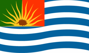
This Republic of Cascadia flag is one of many. Cascadia is a proposed independent nation in the Pacific Northwest, usually composed of Oregon, Washington, and British Columbia, that would be formed by seceding from the United States (and Canada).
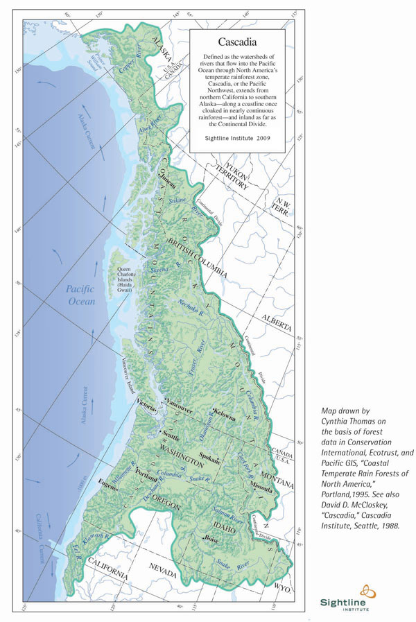
Water and Forests According to Sightline Institute "Cascadia is defined by water and forests: it encompasses all of the watersheds whose rivers flow through the temperate rainforests on the northwest Pacific coast."[1]
Statistics of the Republic of Cascadia[2]
Name: The Republic of Cascadia (long form), Cascadia (short form)
Capital: Cascadia
Area: 855,762 sq km
Population: 14,220,981 (2005 est)
GDP: US$323 billion (1996 est)
Language: Cascadese (a dialect of English)
Time System: Metric Time
The Cascadia Subduction Zone stretches from northern Vancouver Island to northern California. It is a very long sloping fault that separates the Juan de Fuca plate and North America plates .
The Cascadia Subduction Zone Quake will generate two Tsunami waves, one propagating towards the coast, and the other towards the deep ocean and Hawaii .
It will take only minutes to reach the coasts of Oregon, Washington, southern British Columbia, and northern California with wave heights reaching close to 12m (~36ft) in some scenarios.
...MORE...
References 
