File:Mt Tabor reservoirs MapQuestOpen.jpg: Difference between revisions
Jump to navigation
Jump to search
(MsUpload) |
(notes) |
||
| Line 1: | Line 1: | ||
Map of Mt Tabor with reservoirs labeled by [[User:kotra]]. Basis is a screenshot of OpenStreetMap's MapQuest Open layer: http://www.openstreetmap.org/#map=15/45.5099/-122.6016&layers=Q | |||
Other map data is copyright OpenStreetMap contributors, and is freely available under the Open Database License (similar to CC-BY-SA). | |||
Latest revision as of 13:29, 23 September 2013
Map of Mt Tabor with reservoirs labeled by User:kotra. Basis is a screenshot of OpenStreetMap's MapQuest Open layer: http://www.openstreetmap.org/#map=15/45.5099/-122.6016&layers=Q Other map data is copyright OpenStreetMap contributors, and is freely available under the Open Database License (similar to CC-BY-SA).
File history
Click on a date/time to view the file as it appeared at that time.
| Date/Time | Thumbnail | Dimensions | User | Comment | |
|---|---|---|---|---|---|
| current | 13:10, 23 September 2013 | 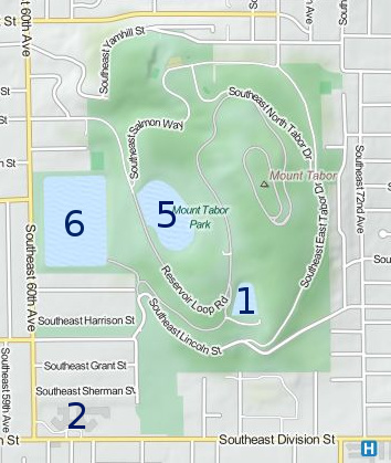 | 354 × 419 (71 KB) | Kotra (talk | contribs) | MsUpload |
You cannot overwrite this file.
File usage
The following page uses this file: